There are predominantly two kinds of roads that can be driven or ridden "off tarmac", BOATS and ORPAs. The best way to locate the physical location of these lanes is to look at an Ordnance Survey (OS) map. Once you have identified where the lane is, you need to establish whether or not it's legal to use a motorised powered vehicle (MPV) on it. For BOATS they should appear on the definitive map, for ORPAS they should exist on the List of Streets as "maintainable at public expense". If in doubt ring the council and double check. Alternatively you can look on SmartTrail and check with your local All Terrain UK Ambassador.
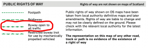
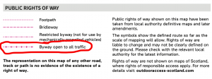
BOAT - Byway Open to All Traffic - part of the Public Rights of Way network, and will appear on the Definitive Map for the county. Some councils have an online version of the Definitive map.
1:25K scale
1:50k scale
1:25k scale

1:50k scale
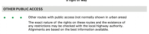
ORPA - Other Route with Public Access - these were also traditionally known as UCRs - Unclassified County Roads - part of the Highways network.
Other parts of the Public Rights of Way network such as footpaths, bridleways and restricted byways are not permitted to be used by motorised vehicles.
Forestry England do not allow the general public to use motor vehicles in their land (including Forests).
Some Ministry of Defence Estates (such as Salisbury Plain) do allow access on Permissive Routes but reserve the right to close them at any time to the public with immediate notice.
